Friday, June 14, 2019

Mesa Verde National Park


Mesa Verde National Park

Mesa Verde is a fantastic look into the Pueblo people who made it their home for over 700 years, from 550 to 1300.  The Park Service protects 5,000 known archaeological sites, including 600 cliff dwellings.  We did not see all of these items as we only had a couple of days stay here so we hit the hi-lights. 


The Mesa Top from Pit House to Pueblo

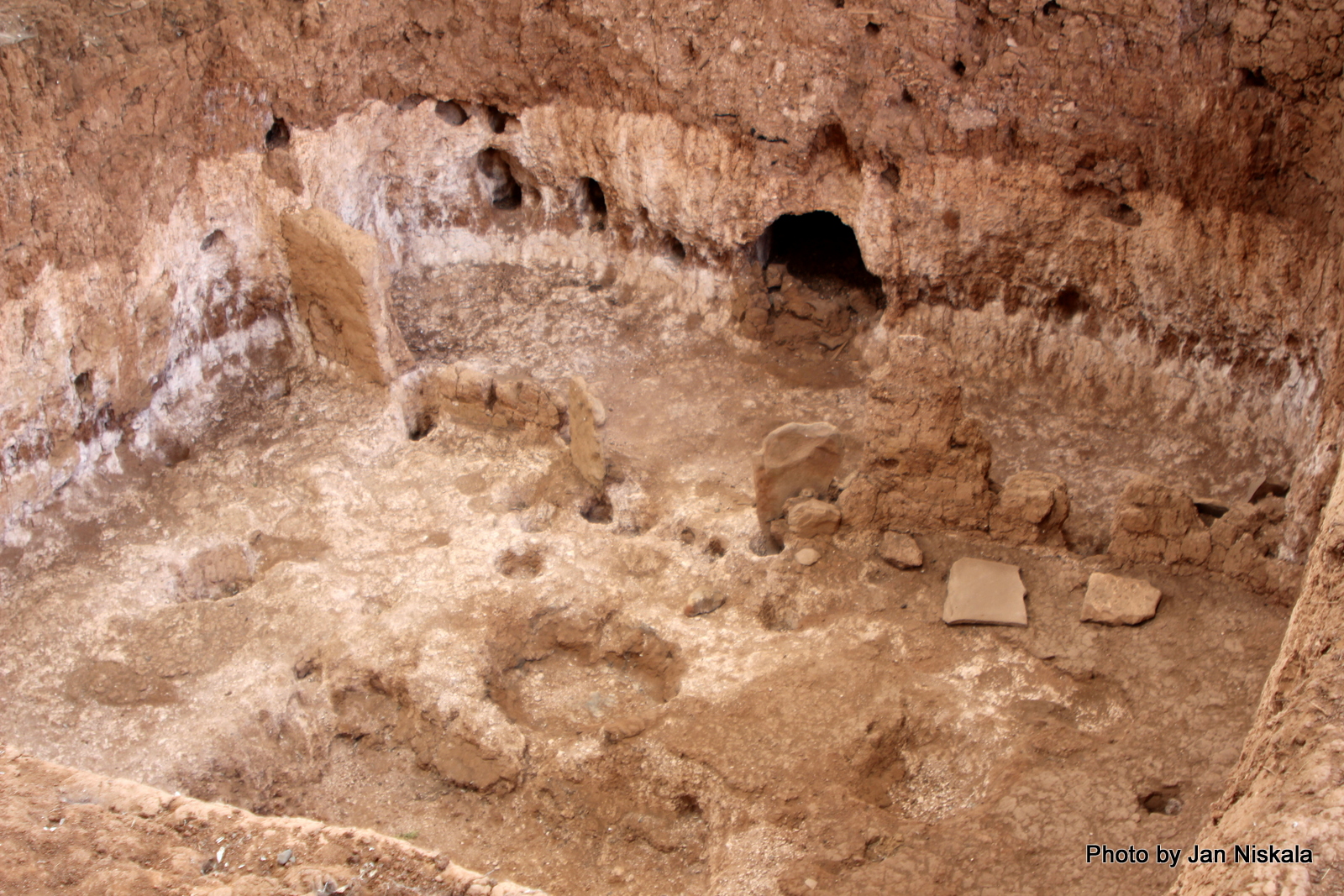
The homes and religious structures of the Ancestral Puebloans, who were found to live in this area from around 550 to 600, were simple modest dwellings consisting of shallow pits dug into the ground, covered with pole and mud roofs and walls with entrances through the roofs.  The original walls and roofs have long since returned to nature.


Each home was set up similarly with a large space, used as a general living space, with a fire pit used for cooking and heating the home.  There was a large flat stone slab placed in front of the fire pit to keep air circulating, both deflecting cool drafts and drawing smoke up and out of the home.  Each had a smaller room to store food and fire wood.  Imagine living in this dim pit house with extended family, parents’ children, grandparents, all sleeping on the floor on twill mats, trying to keep warm on winter nights ….. hhhmmm  … I think I’d miss my comfy bed!!!


 Between 700 and 950 there were significant architectural developments.  The Pitt Houses were dug deeper into the ground … about four feet down, and they often built over an original pit house making improvements.  For example instead of venting the fire pit up through the roof of the house they now built a vertical ventilator shaft in one side.  Gradually by 850 homes were being constructed above ground.  The foundations were shallow slab lined pits, they usually  had a series of rooms covered over with mud.   By 950 the homes consisted of the Pitt House with low rock walls, the Deep Pit House with four foot deep walls, one or two above ground rooms as well as a Kiva – a round four foot deep structure with slab covered walls which were used for seasonal ceremonies.


The Cliff Dwellings

Spruce Tree House, shown below, is the third largest and best preserved cliff dwelling in the park.  Built into a natural alcove between 1211 and 1278 it contains 130 rooms, eight kivas and may have housed  60 to 80 people. 


 Cliff Palace, shown below, is the largest cliff dwelling in North America. From the rim top overlooks the collection of rooms, plazas and towers fits perfectly in the sandstone overhang that has protected it since the thirteenth century.  While it is impossible to know why Ancestral Pueblo people decided to move into the cliff side alcoves building elaborate and expensive (for that age) structures (like Cliff Palace) a series of sciences including archeology, ethnography and dendrochronology along with a host of other disciplines have offered us insights into this era in this regions history. Many have worked on excavating and repairing the crumbling walls since the discovery of the Palace, especially Jesse Walter Fewkes of the Smithsonian Institution in 1909.  The scientist can only speculate as to why the people decided to live in cliff dwellings.  Perhaps the dwellings were similar to our capital cities, a place for administrative  or community centers with the 100 to 120 residents acting as ‘caretakers’ of stored crops, who performed maintenance to help distribute the stored crops and coordinate special events for the hundreds of people from outlying communities.  We can also only speculate why these Ancestral Puebloan peoples had moved on by the 1300’s.  Perhaps due to a long drought at the end of the 1200’s causing crops to fade and the larger animals needed to feed the people to move on as well.

The history and knowledge learned is the same for all of the cliff dwellings in the park.  Enjoy the photos below while you imagine yourself living during this time period, in a cliff dwelling.  


Sun Temple
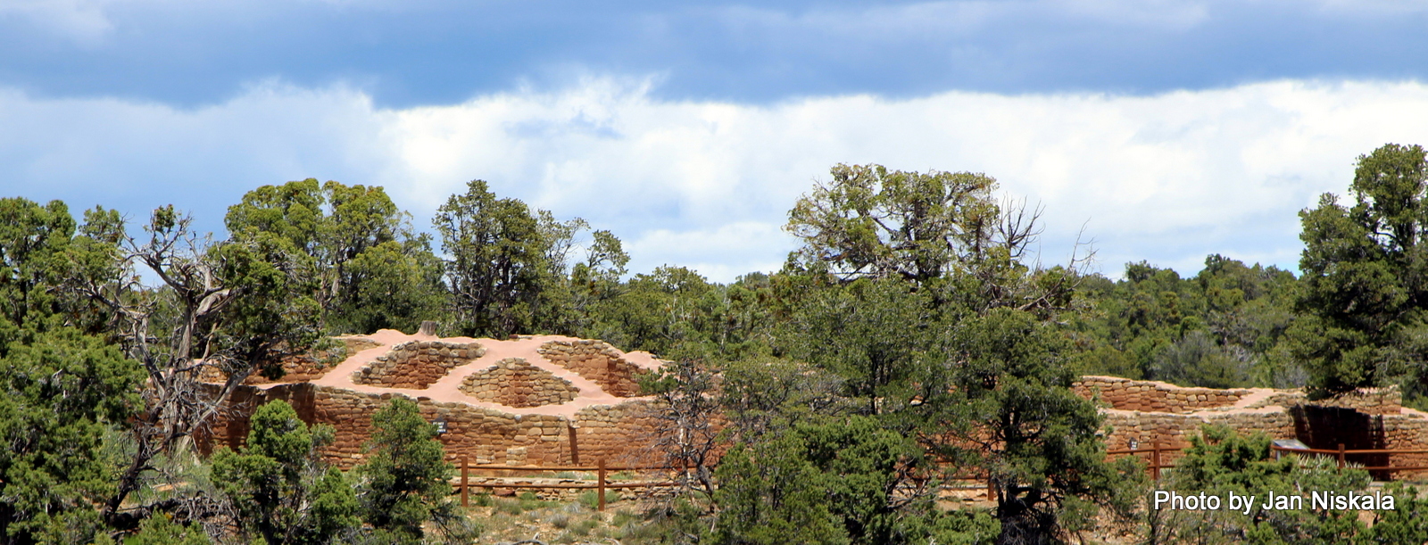
There is a structure discovered in 1915 the scientist believe was constructed as a place for worship.  It is a “D” shaped structure and is much larger than anything else found from this time period in this area. It was carefully constructed with four foot thick double walls that were all filled with a rubble core.  Every stone was carefully chipped so that the surface created finely masoned walls.  There were no household goods or roof beams found indicating that the structure of nearly 30 rooms was probably never completed.  We could not go inside of the Sun Temple but I managed to get a few shots of it from across the canyon and of the halls at the entrance. 


There were many additional ruins that we were able to view including the Square Tower House, the New Fire House and Fire Temple, views of the valley, and of course there are always flowers and other interesting things to photograph.  Enjoy!


 The view as we drove into the park!


More to come soon  😊 πŸ•

Jan  πŸŒ·πŸŒ·πŸΎπŸΎ     


Monday, May 20, 2019

Horseshoe Bend a Bloggette !


Horseshoe Bend

This is a Bloggette because my photos will say it all!  Horseshoe Bend is, obviously, a horseshoe-shaped turn in the Colorado River located near the town of Page, Arizona.  As you’ll see in the photos below Horseshoe Bend is a beautiful, peaceful natural beauty that allows visitors long quiet moments to enjoy the beauty of nature.  It’s also an awesome view!  The overlook is 4,200 feet above sea level, it’s an easy walk from the parking lot and it’s free to spend as long as you would like enjoying the tranquility of the area.  Even though it’s become a very popular of late you can always find a quiet spot to enjoy your visit.


 More to come soon  πŸ’•
Jan  🌷🌷🐾🐾 

Sunday, May 19, 2019

National Natural Landmarks


National Natural Landmarks


During our wanderings around this very big and very beautiful country of ours, we have come across National Natural Landmarks.  The National Natural Landmarks Program is responsible for recognizing, as well as encouraging, the conservation of potential sites that show outstanding biological and geological resources and features.  Landmarks are selected for their outstanding condition, illustrative value, rarity, diversity, and value to science and education according to program guidelines and are designated by the Secretary of the Interior.  These sites may be owned publicly or privately and acceptance of the designation only comes with landowner concurrence.  As of 2009 we have 600 landmarks that have received the NNL designation within the United States, American Samoa, Guam, Puerto Rico, and the U.S. Virgin Islands. 


So because the sites are super interesting and sometimes really unusual we have added them to our ‘Gypsy travel bucket list’!  We have seen a few of these already but only by accident, you know being in the right place at the right time and hey … there’s a National Natural Landmark!  Some examples include Joshua Trees forest, Lake Tahoe’s Emerald Bay, La Brea Tar Pits, Sonora Caverns, Palo Duron Canyon and most recently the Barringer Meteor Crater, which is our Blog Chapter for today

 Barringer Meteor Crater is the largest impact crater yet discovered in the United States. The impact occurred approximately 50,000 years ago from a meteor weighing several tons and when the local climate was much cooler and damper. The area was open grassland dotted with woodlands inhabited by mammoths and giant ground sloths.  

The meteor that excavated the crater was a nickel-iron meteorite about 160 feet across. The speed of the impact has been a subject of some debate. At first it was thought to have hit the earth at about 45,000 mph but more recently research suggests the impact was slower at 29,000 mph. It is believed that about half of the impactor's bulk was vaporized during its descent through the atmosphere.

Since the crater's formation, the rim has lost 50–65 ft. of height due to natural erosion. Similarly, the basin of the crater is thought to have gained 100 ft. of additional post-impact sedimentation from lake sediments.  These erosion processes are the reason that very few remaining craters are visible on Earth, since many have been erased by these geological processes. The relatively young age of the Barringer Meteor Crater, paired with the dry Arizona climate, has allowed this crater to remain almost unchanged since its formation. The lack of erosion that preserved the crater's shape, helped lead to this crater being the first crater recognized as an impact crater from a natural celestial body in the United States.


 Here’s an interesting note: During the 1960s and 1970s, NASA astronauts  trained in the crater to prepare for the Apollo missions to the Moon.  Look closely and you can see a cut out of an astronaut and an American Flag permanently placed in the Meteor Crater in honor of the NASA Space Program.

The photo above also shows a lot of left over ‘stuff’!  These are the remnants of various science related groups attaining and completing research within the crater. 

 
More to come soon  πŸ’•  
Jan  🌷🌷🐾🐾